Sunday, October 01, 2023

Donnell Vista: Scenic or Tragic?!

 We have entered October which means I get a little on the spooky side. What it looks like is going to happen is I will officially start my "Ghosts of the Past" Halloween series later this month. I have some commitments I have to keep so I do not want to start anything until those are taken care of. So, I kind of look at this blog entry as a prelude to what I will be doing. However, I want to make it clear that what I am showing here deals with real world unsolved mysteries that friends and families are still seeking closure to. So, I am going to be sensitive, serious, and matter of fact about how I explain this one.

Back in August, 2005 my brother and I had just completed two major mountain scrambles that either border Yosemite or are in it. We were very excited, came home, and I was looking at the local Eastern Sierra news. I noticed that a woman, Nita Mayo, from Hawthrone, NV had gone missing during the days I was doing those hikes. Her car was parked at Donnell Vista past Sonora Pass on HWY 108. I remember some special searches the locals did up until the winter. Over the years I have checked into anything that was said about this since she was never found.

Then in 2014 another woman, Patricia Tolhurst, went missing and again her car was found parked at Donnell Vista. Then in 2016, Breck Phelps, was fishing nearby and his car was found about 1/4 mile from Donnell Vista. None of these people have been found. I will link a few articles that go into more detail below.

Donnell Vista has become a very mysterious place to me. I had all these ideas in my head of how the place should look like and how isolated it must be. If I ever went to this place, should I bring weapons? Two years ago in October I decided to make a visit just to see what the place is like. No, I did not bring any weapons. 

So, after driving on HWY 108 for what seemed like about an hour of going up, down, back, and forth, my brother and I got to the small turnoff parking area that serves as a rest stop for people traveling by. You do get some good views of the area with lots of forest trees around.
There is a major elevation drop off and you can see Donnell Vista lake below. 
If you look carefully, you should see the dam at the end of the lake. From what I understand this is a major source of water for the towns on the western side of the Sierra. Coincidentally, I have read about some of the people crossing this area in the late 1800s before this lake was here. It was a major trek trying to get through the river and down below.
Looking at the dam. Again, the area has a nice trail and lots of trees like this surround the area. You are pretty safe walking around the paved trail here. However, if you go off trail and fall down it might take quite some time before you are found again. Keep this in mind.

This is part of the parking lot. It goes into a circle from the main highway. If you look carefully you can see the rest rooms in the middle of the picture.

The rest rooms. The paper that shows Nita Mayo as missing is the middle there and can be seen in my video. Interesting enough, another person that went missing a month before I visited and is still missing was listed right next to her, but that was somewhere in Yosemite. Many people have gone missing there to never to be found.

Let me give my assessment before I link my video and some of the articles I have seen. This area is isolated, but not as isolated as other places I have been at. There were a bunch of cars parked, families walking around the trail, and I never got the feeling I was ever really alone there. Lots of cars passed by as well, and there are campsites a few miles in each direction. So it was not as isolated as I had imaged it would be. Keep in mind this was in October in middle of the day. I am not sure what it is like during other times in the year or earlier or later in the day. 

Yeah, the terrain is one that if you make a few mistakes you might not be found for a long time. Yet, it is hard to imagine not being found eventually over a period of time. This is puzzling.

So, my conclusion is that in at least one of these cases foul play probably happened. I do not know enough about each case other than what I have seen on the internet and newspapers. So, I do not want to say anymore than that. If you follow this blog you know I always say something like, "nature does not play by rules." Well, when you are travelling in isolated areas that same idea applies. You need to be prepared for not only nature, but people you could encounter. 99.999% of people are good and helpful, but there is always that tiny % you just do not know about.

The video covers what I showed here, but I also used the opportunity to show some of the terrain one encounters in clips back to Sonora Pass:


Some articles:


Saturday, September 16, 2023

Flying Over Dana Point (Part 2)

 Continuing from yesterday, this is my drone flight over Dana Point, but near the harbor.

This is the opening where all boats from the harbor must go to get to the open ocean. I usually whale watch with Dana Wharf which would be in the upper center part of the picture.
This is heading back to where I was hanging out near the breakwater.

The Ocean Institute is mid-center on the right. Lots of kids go there to learn. I know some public schools have their kids raise money to go there. I know parents that send them there for the summer programs that were going on while I was there.
Finally, upper center is the kids beach location that families can take their little kids to for a beach experience. Although I have not spent much time there, I do think it is a great place for the little ones since it is pretty safe from what I can tell. 

In closing, I love going to Dana Point a few times a year. It is a nice area that is relatively easy to get in and out for tourists compared to the other beaches in the Orange County/Los Angeles area.   

Friday, September 15, 2023

Flying Over Dana Point (Part 1)

 The next "Fly Over" I wanted to show was a drone flight I did back in July. Turns out I went a few times both to fly the drone and to whale watch. I flew the drone each time I went, but only once was the weather clear enough to what I was after. That is what I will be showing.I flew from the around the breakwater out to a bunch of boats and then looked back at Dana Point right here. There is a nature trail you can see on the land that I will have to investigate someday. I know you are not allowed to fly drones from there, so I did not even bother trying to do anything there.

This is looking toward Laguna Beach. It was nice to get this shot since I could not see Laguna Beach from where I was at. 
More of the rocky Dana Point.
Looking back at where I was at and Dana Point Harbor. In theory, on a low tide you could walk all the way around you see.

Tomorrow I will continue this showing the harbor area.

Saturday, September 09, 2023

Flying Over Lundy

 In the past few years I flew one of my older drones over some of the lakes and other Eastern Sierra areas that I called "The Silmaril Series" to highlight a few gems with aerial photography. I decided to transition into something I am calling the "Flying Over..." series. I have gotten a little braver in flying my drones longer distances. The emphasis is more on my videos in doing this than the pictures, but I will still take pictures. In the future there might be some repetition as I might fly over the same areas, but hopefully during different times of the year or with other weather conditions. Also, it is mostly over lakes for now, but if I see dry areas I think are worth flying then I will show them.

So, there was a long winter this past year that really caused a lot of water runoff in areas I had never seen streams before. In May, the ice and snow had not quite melted as it would through June and July which created new streams. When I was in the Eastern Sierra during May I noticed a lot of lakes had a murky look to them where trees and other plant life were in the water due to the high levels of the lakes. However, when I went to Lundy Lake the icy snow on the mountain side had not melted yet. I assume a lot more water went into the lake over the summer because of this.

So, I flew the drone from the other side of the lake and took this picture. A bunch of people were fishing at the lake.

As I pointed out, a lot more water was going to get into that lake this summer. 

This is from the side I launched from which is by the "town" of Lundy. 

I circled the house (with a blue color) that collapsed with too much snow over the winter. A lot of houses and cabins needed repairs this past summer.

Please check out this video I did for this on Youtube:

Wednesday, April 19, 2023

Memories of Lago

 So today marks the 50th anniversary of the U.S. release of High Plains Drifter. It came out on April 19, 1973. Like a lot of movies, it did have a limited premiere release about two weeks before for a few cities, but I decided to use today's date as the official 50th anniversary. I started to prepare for this date about two years ago.

Yes, I had thought about another trip to Lago over the years. The pictures and video I took way back were good for the time, but over the years I told myself if technology improves where I can video the place at 4k and 60fps then I will do it again. Then during the pandemic period I watched a lot of blu-ray commentaries. One being High Plains Drifter with director and Italian western historian Alex Cox. It was after that I decided I need to get back to Lago, and another place that will be for some other time. 

There was a slight disappointment since the last time I had been here. When I came back during the summers of 2021 and 2022 some things had definitely changed. The dirt road has more sagebrush overgrowth on it now. 

You can definitely see it in my picture below compared to the movie picture. The main dirt road is still there, but the road one hikes to in order to get to Lago is missing. Well, sort of, I can see traces of it in my picture if I compare to the one above.
It used to be there was a sign warning people not to drive vehicles in that could not handle the dirt road there. I never drove in there since I have never had the vehicle that does it. I assume most people would not.

Here is what I was told. A bunch of people that did not have the proper 4WD off-road vehicle went in and were getting stuck in the area. So, the powers at be just blocked the road off. You can still hike in like I thought most people would do, but the issue is that now the sagebrush is growing all over the old dirt road.
So compared to what I was showing back around 2010-2012, the road through town is not as obvious.

Fortunately, as I was walking, I could tell where the dirt road through town was. The rocky tufa formation on the left is still there. It was a situation that you can tell when you are there, but it is not as obvious in my pictures.

So, this is another reason I am a little down on letting the public know exactly where certain areas are now. It is not like it used to be. All it takes is a few people to mess things up by being careless that it ruins it for everyone else. 

I say in the video it would be nice if some people got together to restore the dirt road for fans of the movie. I know that is not realistic these days, but you never know.

The video I think works, but the conditions were not what I had hoped for. Lots of clouds making it really hazy. 

Memories of Lago (Youtube)

With that out of the way I originally had planned a total of three videos to be released by around this summer. The second video I had put together was a "Silence of Lago" that used alternative footage. The third video was the same area as the video I call "Clint Spooks 'Em". The second video has the same hazy weather conditions as "Memories". So, I am putting that one off until I can go back on a different day. The third video will come out at some point, but I am not sure when that will be. So, I am not done with this area. 

This is the U.S. version of High Plains Drifter with the commentary I was talking about. It has the 4kHD and the regular Blu-Ray: HPD on Amazon.com.

For all my old blogs on this site click the label here. Please note it starts with the latest blog and goes all the way back as you scroll down: Mono Lake Clint Eastwood High Plains Drifter.

Music used in the video: 

"Western Streets" Kevin MacLeod (incompetech.com)Licensed under Creative Commons: By Attribution 4.0 Licensehttp://creativecommons.org/licenses/by/4.0/

Sunday, February 19, 2023

Fishing for an Assassin (Part 2)

 In the last blog entry, I showed some of this location I found north of Yosemite near Sonora Pass. I noted that in the movie Out of the Past the area seems very compact, but in reality this scene was filmed over a few hundred feet of the location.

Initially we see Dickey Moore fishing, Joe stands on a cliff where he intends to kill Robert Mitchum across the river, but Dickey Moore casts his fishing hook in time to snag Joe, and then pulls him so he falls to his death in the river. The following picture has Dickey and Robert looking over the body of Joe:

Here is that exact same spot. The trick however is that this location is a few hundred feet down river from the pictures of the last blog.
Then Robert Mitchum talks to Dickey Moore about him being followed and stuff right here:
To get that I just moved to the right side of the picture I took above to get something like this:
Since the water level was not so bad at the time I was here for this trip I decided to investigate the rocky river here. Disclaimer: early in the year this could be a really bad thing to do. No matter what time of the year one is near fast moving water one should be extremely careful around slippery rocks. If one falls here they could end up like Joe in the movie.
In the picture below I was standing where Dickey Moore was and Robert Mitchum would have been standing on the rock with the partial tree trunk laying on it right in front of me.
So knock this one off my "to do list" If I am ever in the mood to reboot my OOTP video I will probably add this location to it. In the meantime, enjoy the video I did here:

F.F.A.A. (Youtube Video)

Friday, February 17, 2023

Fishing for an Assassin (Part 1)

Years ago I did a bunch of the locations for the movie Out of the Past. I knew a good portion of where the High Sierra locations were filmed at. One of the scenes that only takes about a minute or so always eluded me. Sure enough over the years it is the one many of you have asked me about. I would list it as one of the top two or three most requested locations. 

This is the scene where actor Dickey Moore has been followed by Joe (Played by Jack Valentine) to where Robert Mitchum is camping. Joe intends to murder Robert Mitchum. Dickey is fishing, Joe attempts to shoot Mitchum, but Dickey casts his fishing hook just in time to snag Joe. Dickey drops Joe to his death in the water below.

It is a good scene, but trying to find an isolated area on a stream out in the middle of nowhere is kind of like looking for a needle in a haystack. But, with that said, over I would say around the past fifteen to twenty years I have kept this scene in the back of my mind. It was a location on the "to do list". When my dad was still around, he would tell me Walker River near the marine base. In any case, I did find it using some of the techniques I have discussed on this blog and narrowed it down. It turns out my dad was basically right. It is very close to Sonora Pass. 

The interesting thing is that you see them drive to a spot off the June Lake Loop. Years ago I looked around the June Lake Loop for this picture, but what you see was actually done about an hour to the north of there near Sonora Pass. 
It is a little difficult to compare here because of the shade, but keep trying. The rocks on the left side should be helpful to see that this is it. You should see where Dickey Moore would have been on the rock next to the tree on the right side of the picture. Unfortunately, I did not get a good shot of this for the video.
So, they show Joe here looking down at where Dickey Moore is fishing. What is interesting is that the trees can be identified and are still here after all of these years. 
Normally I do not like to use trees as a reference point because rocks tend to be "more permanent" in the scope of a human lifetime, but in this case these trees work! I am actually where the camera would have been to film this scene. I show it in the video where you can see some of the rock right in front of me as Joe goes down below.
For this picture I moved to my left compared to the previous picture. You can see where Dickey Moore would have been fishing by the tree below. When I did this I assumed they had Joe move over the rocky pillar just left of center. They then show Mitchum across the stream camping with Dickey Moore below. If you saw the movie and then came here like I did you would assume it all played out right here.

I am not so sure of that now. They did some quick cuts with Joe and Dickey Moore that do not really work for this spot. I am sure they filmed those quick shots around here along the river, but I would have to go to the other side of the stream to verify what they did. 

 In any case, I did get what I wanted out of this location. The trick to this area in the movie is they make it look like it is very compact. The reality is they used a few hundred feet of the area to create this scene. I explain more in part 2.

Sunday, January 29, 2023

Housekeeping 2023

 I am a little late on this blog. I had a few technical issues that I wanted to take care of before going into this. If you follow the blog you probably already know about most of this. I created a video I link that goes over the various issues for people that watch my videos and probably do not read the blog. A lot of this I have said before, but let me restate some here:

#1 I don't do Ads of any sort. If you see ads those are not of my doing. The internet is destroying itself with constant ads. There was a time when ads were rare. Btw, this is one of the reasons I am a bit sensitive about leaving comment sections open going back many years. I realize we live in a capitalist society, but scammers and just anyone that wants to try to sell something usually like to invade comment sections. 

#2 I do not give out GPS coordinates anymore. I started this policy last year, but many who do not read the blog still have e-mailed me so I am stating again and now in video. I am keeping up what I have had in the past, but no longer will in the future. I explain it a lot in the video below with examples, but it has to do with geotagging, too many people are showing up to isolated areas that are not designed for loads of people, and these people do not have the same values and love as others before them in regard to these locations.

#3 I have new Go Pro camera, microphone, and computer! What this means is I will be using this new technology in a slightly different way than in the past. I am trying to make my videos in 4k (or 5k) so one can watch them on a bigger tv screen. Most of the videos I have done in the past in 1080p were good for the time, but these days the quality is a little dated. They still work on smaller screens like cell phones and tablets, but I want to work for bigger quality screens. I have already done the first video I will release next month and I really like it. 

One downside is I am probably not going to add movie video clips on to my videos like I used to. I intend to use a lot more still pictures instead. It is a lot of work to do video over video like I did in the past and getting everything to line up. Then there is different "frame rates" and issues of copyright that I do not have time for. Also, just about any video I have done in the past I might "reboot" with a new version if I am in the mood. We shall see.

#4 I am not looking for work or other projects to do right now. I had a few e-mails last year about this, but I do not have the time right now.

#5 I could use the help on a potential project in the future if you or you know someone who is a mountain scrambler with a Go Pro 10, 11, or whatever they release in the future. I am getting to the point in life where a lot of the mountain scrambles I did when I was younger are no longer on my list of things to do. I am relatively healthy and in some shape, but definitely not the way I was ten to fifteen years ago. My main thing is I just do not have the motivation as I have in years past...too many years of getting in shape just to find out the Eastern Sierra was on fire! Lol! 

This would be a completely free venture. Just for the love of the experience. Basically, I would explain some of the way I like to do video to the person, the way I hiked the location in the past, then they would go hike it and take video in the summer. I would then edit the clips of video given to me and narrate my memories of the hike. I would give full credit to the person(s) doing the hike and video.

I am going to use Matterhorn Peak as my example. I have old video of this hike, but it goes back to the vhs era and just does not work. So if you know someone or are someone that thinks this would be a fun thing to do then let me know: thegreatsilence@mail.com

Not something I expect too many replies on, but it was something I have put some thought into this last year. 

Housekeeping Youtube Video (2023)

With that said, I intend to cover a location I have been asked about a lot over the years, but never knew exactly where it was until a few years ago. Sometime in February!

Sunday, January 01, 2023

The New Year Has Come! (The Silmaril Series)

Merry New Year! I hope you are simply having a wonderful holiday season. As I have stated before I have a tendency to think of Christmas time continuing until about the second weekend of January (or whenever Martin Luther King's birthday holiday is in the U.S.). So, I typically have what most would consider Christmas music in my mp3 player until then. Keep in mind I do not really listen to the popular Christmas music you hear on the radio during the season. I always enjoy taking walks at night listening to my music and seeing what houses are still decorated with lights. It gets less and less as the weeks go on, but I have seen some Christmas lights out until March before. 

Skipping back to my previous December 21, 2022 blog entry, I showed what happened back in May, 2022 when I hiked to Leavitt Lake. It was a strange weekend, but I was somewhat happy to get some sort of picture of the "winter-like" conditions there.

So, we went back about two months later near the end of July. This time the issue was there was a lot of smoke due to fires going on. Again, this was frustrating. I was a bit fortunate in a few ways:

So, as one should expect during the summer, all that winter snow and ice was gone. The only downside I had was a small amount of smoke haze I had to deal with here. You have to look really closely, but on the right side in the lake is tiny little boat. Some guy was fishing there. There were others camping around the lake with the 4WD vehicles which you need to have to drive into this area. For this blog entry and the one back on December 21st we hiked in on the dirt road. In the past, I have been driven in with 4WD trucks. I have to stress that or someone will get stuck in the middle of nowhere! Do not drive this road unless you have the proper vehicle! 
I did get the drone to clear the lake. This is looking back across the lake. I kept pushing the drone to see if I could get all that pond in the shot, but at the same time I did not want to crash into the side of the mountain as I kept going backwards. So, this is the best I could do. 

The smokey haze was much more apparent in the background. I moved the camera down to focus on the lake. The mountainside was very smokey so no need to show that. You can see some of it on the upper right side.

We did not spend much time at the lake. Just enough for me to fly there and back again. There is more hiking that can be done around the lake. We have talked about doing more, but I hope to do other things before coming back here in the future.

So with that said, we start the new year! I will have another "housekeeping" type of blog entry in the next week or two. I am preparing a video for it that is more for my video watchers than those who read the blog, but stay tuned here since it will prepare how I go about 2023.

Wednesday, December 21, 2022

Winter Is Coming! (The Silmaril Series)

 At least in the Northern Hemisphere! 

So, will be the last blog entry of the year. Please have a great Christmas and New Year! Note that many are coming down with illnesses of various types, including Covid still being around, so please protect yourselves and bulk up on your vitamins. 

So, one of the goals I had this year was to use my drone at Leavitt Lake. This is one of the shots I took:

The trick on this one is I took it during Memorial Day Weekend. I had just re-registered my drone, and the week before the weather forecasts were saying that there would be lots of wind in the Eastern Sierra that weekend. Exactly what I did not want to happen.

Sure enough when we got there it was all very windy. We decided to go up the HWY 108 anyways to see what it was like at Leavitt Lake. Turns out that morning was not too bad for wind, but as we kept going the cloud cover was lower as we kept going higher on the road. 

We parked off the road. Normally one takes a 4-wheel drive to Leavitt Lake, but the road was blocked due to winter conditions still existing, and we were just going to hike the road anyways. Off we went.

It took us about an hour to hike in. A few huge trees had fallen down over the winter so even if the road were open, no one was getting through with any vehicle. As we got closer to the lake the more snow we encountered. In fact, at a few points I was pretty much sunk in knee deep. 

At the lake I had already decided I was going to fly my drone quickly. Go up, get a few pictures, and get down. There was a slight drizzle of rain coming down, but not overwhelming. I took the drone up and flew over some of the lake. 

I flew it back and took the above picture. I was going to do a little more flying over the lake at a lower level, but then the rain started to kick in a little more. I would have liked to have taken a picture of the lake without all the cloud cover around and the sun out, but that was not in the cards on this day.

I ended up flying my drone a few more times that weekend with the wind really blowing. I was kind of fortunate I did not lose the drone, but I had waited many months to fly again. Looking back now I will probably never fly in any type of rainy conditions or that type of strong wind ever again. 

So that ends my flight with winter conditions at Leavitt Lake. There is more to this drone story at Leavitt Lake, but I am going to wait until the beginning of January to tell the rest of the story. 

Saturday, November 26, 2022

The Silence of Gaylor Peak

 As I explained in the last blog entry, I did this part of the hike in the morning. I then visited the mining area after I came back down. While the hike might look intimidating from the pictures I showed last time it really is not. This is because you do not need to climb it from the east side. 

This looks a lot different than what you see from the other side. I would say this is probably one of the easier hikes in the Eastern Sierra. Do not get me wrong, one does need to be in shape and prepared, but it is a little milder than others.

As I said, there are some rough moments when you look straight up. I spent some time zig zagging my way up. Not too far from here I encountered a ranger coming back down. He basically told me I was done, and I kind of figured I was. There were a few false summits though.

At this I looked back. When I came back down, and I then descended to the right toward Gaylor Lake you can see a small part of. 
Now I am at the summit. You can see Gaylor Lake looking toward the west of Yosemite.
This is looking toward the north-west you can see the Granite Lakes in the distance. I did not go to those on this trip. 
This picture is looking north at Upper Gaylor Lake. This picture is interesting because I am now looking to where I was going to be in an hour or two. In the background is the Great Sierra Cabin of Tioga Hill and mining area I showed in the last blog. You will not be able to see it, but the trail is on the other side of the lake that goes by the cabin. 

Finally, looking more toward the east you can see Tioga Lake and beyond that Tioga Pass. I did not show Mt. Dana because the sun was glaring down in that direction. You can see it briefly in the video.

The music from Incomptech.com is called Ice Giants and Either Vox.

As an aside, this video marks the end of a certain way I do videos. I am going to make some changes in the way I do things going forward. This is why I wanted to get this video up. I will talk about this at the beginning of 2023. 

Thursday, November 24, 2022

The Great Sierra Cabin of Tioga Hill and "Dana City"

 Happy Thanksgiving! 

The next two blog entries deal with a Yosemite hike I did a few years ago in October. Why have I waited on this one? Well, I meant to do another hike along with it, but due to fires and other issues over the past few years I never got around to it. So, I am tired of waiting so here we go.

For this hike I am shifting to the very end of it first. I will show the early morning part of the hike in the next blog. For now, I will just say that this hike is started on the eastern side of the entrance to Yosemite. You literally enter Yosemite and then just park beyond the entrance to Yosemite to reach the Gaylor Lakes trailhead.

After going up some switchbacks for about five hundred feet, then descended about the same amount of feet, one encounters the first of the Gaylor lakes, and then one heads more in a north-eastern direction to get too Upper Gaylor Lake. Then one follows the trail up to encounter the remains of this:

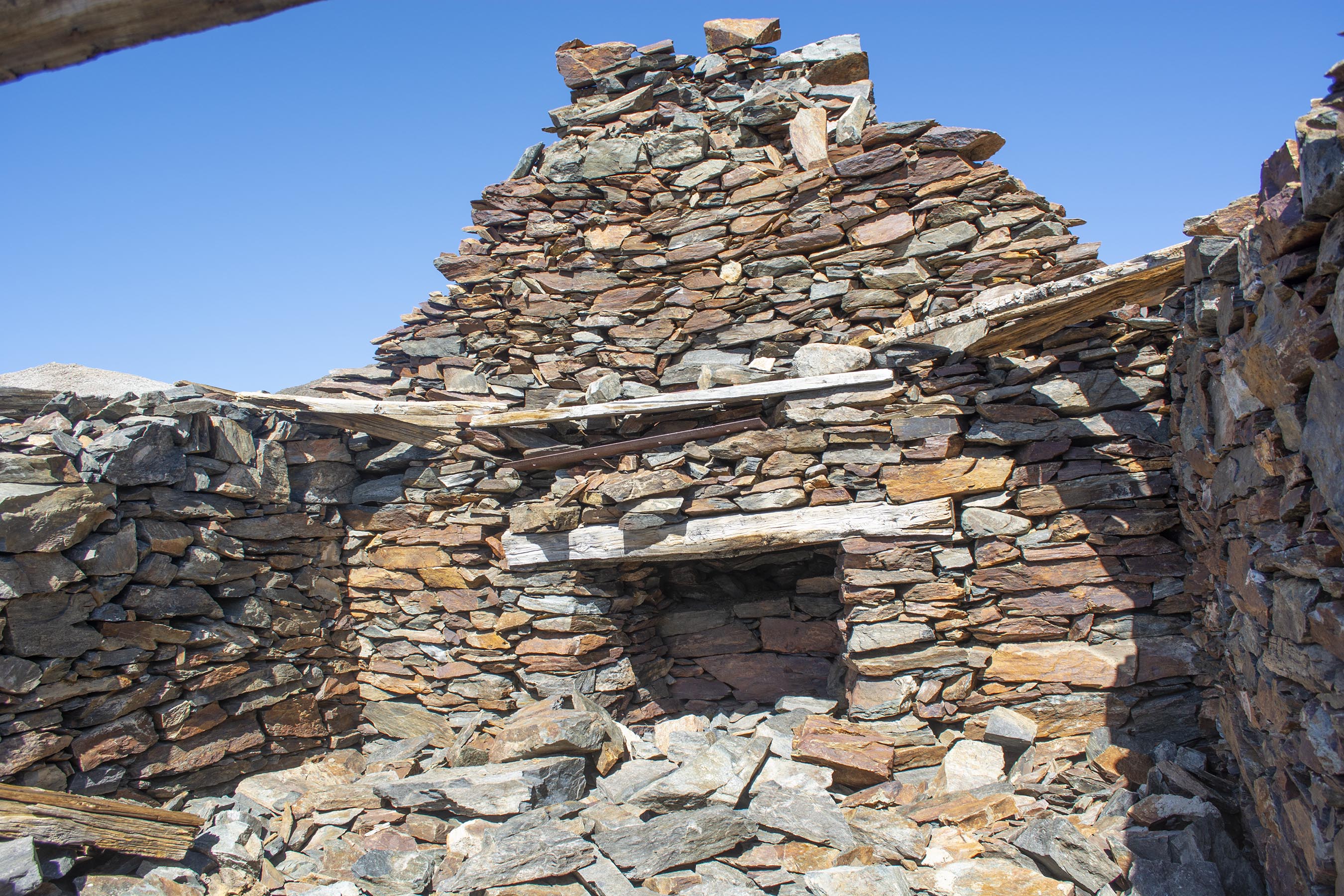
This is known as the Great Sierra Cabin on Tioga Hill. 
Another look of the cabin. There were miners wandering around this area making claims as early as 1860. It was a shepherd, William Brusky, from Sonora that ran into a claim from 1860 during the year of 1874. He worked on the claim until he found a promising vein in 1875. A few years later the Tioga Mining District was formed, and people scrambled to the area.
Inside the cabin I looked at where the fireplace would have been. There were big plans to turn this whole area into a city: Dana City. At some point they planned to make a tunnel that would go from this side to the east to Bennettville. I showed some pictures way back of the mining tunnel they started over there in those 2006 blog entries.
Inside the cabin I framed Mt. Gaylor in the background. This is the view a miner would have had back when it was used. This is actually a common picture I have seen done by others that visit here. Most people that come here take this type of picture out the window. It is interesting to see what time of the year they show. I have seen some fun winter snow pictures here.
Stepping a few paces backwards I took another picture. See the snow/ice inside? I am going to recommend a book at the bottom that has some nice pictures of this cabin when it was still practically covered and complete.

Beyond the cabin heading more to the north-east I encountered a few mining holes. Please note that these holes are dangerous to get to close to. One can slip or the ground might cave in so that you would fall down into the holes. You can get trapped in them with no one around. Also, they did appear very cold. 
Looking in the mine.

 Not too far away I ran across some old mining equipment. Some of it is scattered around.

The community increased, a road was built to get from Sonora to here, and machinery was brought in to Bennettville from over the other side in the east. Yet, it was finally determined that while the mines were relatively good, the remote location, high freight rates, harsh weather, and other issues made it unprofitable. So, the tunnel remains in Bennettville were stopped. Both Bennettville and what was meant to be "Dana City" were abandoned. 

In the next blog I will show some of my hike up Gaylor Peak that can be seen out the "window" in the above pictures. It looks like a pretty mountain hike dramatic doesn't it? Stay tuned...

 While you can find some good information online doing some searches about the cabin, Tioga Hill, and "Dana City," I found that the book Yosemite's Tioga Country: A History and Appreciation by Gene Rose very good. It has a chapter that goes into much more detail that what I described here. Amazon has it much cheaper than I paid for it here.


The music from Incomptech.com is called Ice Giants and Either Vox.