Showing posts with label Mt. Conness Hike. Show all posts

Friday, November 28, 2008

The Mt. Conness Hike (Part 3)

(GPS: N37 58.025 W119 19.280)
 
I knew by getting past the catwalk from the previous entry that the rest of the climb over the rest of the granite blocks would be simple. When I got to the top it was sometime past 11am or so. There was a strange haze in the east and southeastern directions. The views were okay, but not as great as I would have liked for picture taking. I was not too bothered by this since I had good views for some of the nearby areas and had taken pictures from another nearby peak a week before anyways. Really, the fun in this one was experiencing that "stairway."

The following is looking towards the east. Mt. Warren is in the distance, half of Saddlebag Lake is down below, Greenstone Lake is to the left of Saddlebag, and the glacier is just below. Unfortunately, the glacier has that late season dry look to it. There are some positive and negative consequences of doing this hike later in the season, and the lack of snow and ice in the views is one of them.
In the next one you can see Lundy Canyon on the left side in the background. There are a bunch of lakes throughout this picture. There is a trail I have hiked down there that goes around a lot of those lakes, and I had hoped to do it over the last weekend in Halloween to get a picture of Conness from that direction. The storm conditions prevented that so I may have to do that next year. I had never seen those turquoise colored lakes before. I always like those exotic looking colored lakes.
The following picture is not that impressive in itself. It is the northern side of the summit. What is interesting to me is you can see some of Sawtooth Ridge and Matterhorn Peak (my logo) from this direction.
There she is! I had pictures from this direction of it a week before. Usually, there is a heart shaped piece of ice that sticks around until late in the season. It was there a week before, but by the time of this picture it was gone. What you can see is the "easy" class 2 scree filed route to the summit from this direction. In between the Matterhorn and the pyramid looking peak to the far right is Horseshoe Pass which drains all the way to Twin Lakes near Bridgeport. The Horseshoe Pass route from the trailhead at Upper Twin (near Mono Village) is what I usually take to climb this mountain.
This is the western direction. There were some streaky clouds in that direction. This is all Yosemite. I believe the area on the far right is the Hetch Hetchy Valley area. I have never been there, but it would make sense. Yosemite Valley is on the background on left side.
You can barely see it, but Half-Dome is in the very background middle of this picture. I wanted to climb Mt. Hoffman this year which is the high peak to the right in this picture, but that will have to wait until next year.
Here is a zoom in of Half-Dome. The higher peak to the left is Clouds Rest where I have written about before (Part 1, Part 2, Part 3). The fun part here is that little lake to the lower right should be Tenaya Lake. If so, then this we are looking back down at where Ansel Adams took his famous shot of Mt. Conness. Compare with this picture on the Ansel Adams site.
This is the southern side. The highest peak of importance is Mt. Lyell in the background of the left side. I have better pictures of it from a different mountain peak hike.

These pictures really could use a lot of photoshop work, the views are more fun with snow around on completely clear day, and they do not really capture the whole experience of being up there. I hope to go back on a better day. The interesting thing about this hike is that usually being in the backcountry like this I usually see at least one or two people on the way up or coming back. There was no one out there this entire day! I had all this area to myself for this day.
I have one more follow up blog I want do that will cover some interesting historical stuff I found out when I got home.

The Guardian of Mt. Conness (Youtube Version)

For The Guardian of Mt. Conness video I used the following from Incompetech: Heavy Interlude, Coming Storm - Preview A, Mechanolith, Faceoff, and Virtutes Instrumenti. The non-Incompetech Spaghetti Western sounding piece is called "I Diavoli Dello Spazio" from a science fiction movie called Snow Devils.

Thursday, November 27, 2008

The Mt. Conness Hike (Part 2)

(AKA The Exposed Scary Part)
Happy Thanksgiving (for those of us who celebrate it in the U.S.A.)! There is a lot for me to be thankful for. This is a good blog for Thanksgiving day. I am thankful for not slipping to my death on this part! Well, it really is not that dramatic. Let me explain.
 
Back in June I looked at a bunch of pictures I had collected on the web about this part of the final ascent. It is the type of thing that kept me awake a few hours at night thinking about it. Did I really want to do this?
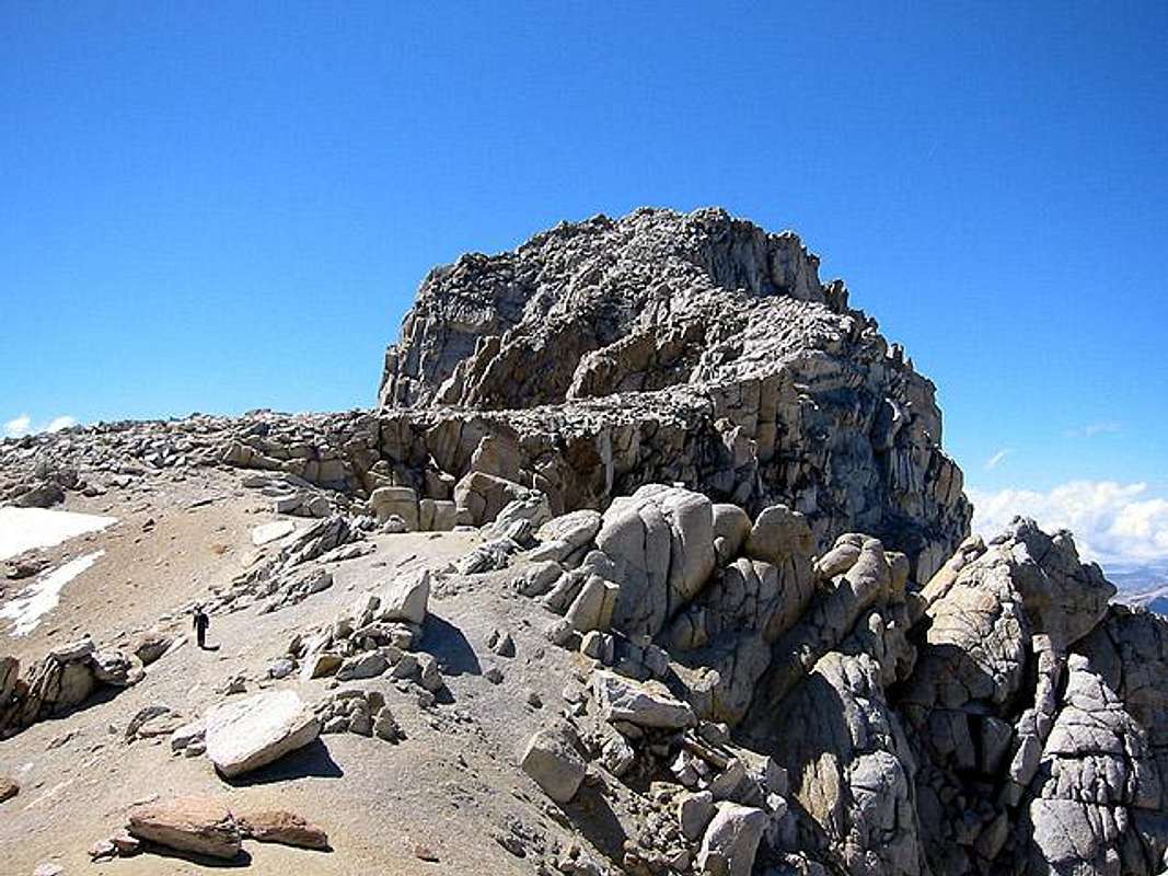
This is about half of the way up on what I refer to as the "stairway." Click this link to see my favorite picture I found online of it. It reminds me of a snake that is rising up. Or, what you might see in a fantasy movie with a castle stronghold at the very top. Although it looks like a true granite rock scramble to the top, it really is not. There is a clear trail through the granite blocks as you ascend higher and higher. It really is easy to climb, but maybe not for those who fear heights. The following is the most "scary" part in that it is the most exposed.
The catwalk above has drop offs on both sides. Then you cross the knife-edge with a little more than a foot in width to walk on. It is about a 10-15 foot crossing. On the right side of me I had the glacier below:
On the left side of me I had this:
Here is this part looking back to where I was just at. I then ascended the rocks to the left of the picture. There was another drop off there too.
Was all of this really something to stress over? Although I probably should say, "Oh this was the most dangerous thing I have ever done! Watch my video! I could have died! I almost did!" I was actually laughing as I was crossing it here. In fact, originally, when I shot the video I did not hold the camera thinking I would need both hands to cross. I realized it really was not that dramatic here, and I could get by with with one hand holding the camera since I had solid footing all the way across. When I came down I tried to shoot more pictures and video of this area to reveal that it is not that scary here, but looking at the pictures and footage at home I realized that I do not think I can show how secure this area really is. The earlier part of the hike where I crossed the pass had more danger issues going up and down. In this area, sure you have to becareful and not make any mistakes, but it really is easy and fun to cross. Of course, if a heavy wind or a earthquake hit at the wrong time...you are much safer here than driving on the streets or freeways where I live. Do not let this part of the hike discourage you if you want to do it.
Both of the above and below pictures are looking back at the snake like stairway that I climbed.
In the background you can see Mt. Dana. Unfortunately, there was some haze in the air that probably went away in about an hour or two because of the angle of the sun. In the next blog entry I will show how the area looked from the summit. The whole "stairway" section only takes about 15 minutes or so. It is exposed with a drop of few a hundred to thousand feet on the sides, but the above pictures are the most dramatic parts of it.

The Guardian of Mt. Conness (Youtube Version)

For The Guardian of Mt. Conness video I used the following from Incompetech: Heavy Interlude, Coming Storm - Preview A, Mechanolith, Faceoff, and Virtutes Instrumenti. The non-Incompetech Spaghetti Western sounding piece is called "I Diavoli Dello Spazio" from a science fiction movie called Snow Devils.

Wednesday, November 26, 2008

The Mt. Conness Hike (Part 1)

(GPS: N37 57.145 W119 18.665)

This will be the first of a few entries on this mountain hike.

Two years ago when I was on Tioga Peak I viewed the area I would hike and climb this year. Last year, after I had climbed Mt. Whitney about two months earlier, I attempted this hike the day after my drive from So. Cal. For some reason my legs were just not moving right. After taking longer than I thought I would to get to where my pictures will start in this blog, I turned around. At that time I thought I would never be able to get to the base of Mt. Conness, not to mention the summit.

This year, after climbing another mountain the week before, I reached the summit. Since I had just climbed another mountain, and had climbed Mt. Whitney a month before, I was not as motivated to do this one. I was relaxed, but also ready to turn around at any point if I did not like the conditions.

I took a ton of pictures and video for this hike. I am skipping the first part of the hike which starts near Saddlebag Lake. Basically, after about two hours of going through an alpine forest I finally reached the following area:
This is the south slope from the east side. There are more direct routes to Mt. Conness, but this is the easiest one to do. The key is you have to be here later in the season or it will have too much ice. If one has an ice axe and crampons then one could try this, but mistakes can be fatal. Since it was not a great snow season there was really no issue here, but going down was kind of slow and rough.
This is near the very top to get to the pass. I had seen the rectangular rock at the very top online in someone else's pictures. I saw it from way below when I was there, and it was my target to get up to. It took about thirty minutes to get to the pass which is filled with scree and class 3 rock. In all honesty, even when you see the later sections near the end of the hike to the top, this is probably the most difficult part of this route.
I looked back down from where I had climbed. I then looked to the right of me which is in the northern direction and saw where I had to go next. There is a trail in the sand here which was good to see.
I looked back and saw how far I had come in about two and half hours.
It is always fun to find different ways of entering Yosemite apart from the main vehicle entrances. You may not see them in the picture below, but you should be able to click the pictures and see two different lakes. One down below is really marshy looking like a jigsaw puzzle. The other is in the distance.
At this point I was just glad to have gotten over the pass and much further. I knew for sure I could reach the base of the summit (aka the summit plateau). Whether I could get to the top or not was a different story. It took another thirty to forty-five minutes until I finally saw the actual peak summit.
There is a famous Ansel Adams picture of Mt. Conness that is taken from Tenaya Lake. The mountain top can be seen from other areas, but from the area at Saddlebag Lake I started at one cannot see the top. I had hoped to get more around Saddlebag Lake to take pictures of it during the last weekend of October, but the storm conditions were too bad so I did not even bother trying.
There still is some gradual uphill hiking here, but it is all trail. Much like other summits I have climbed there is a good portion of it like walking along a sandy beach, but with a bunch of granite rock around.

At this point the final ascent to the summit starts to look like a stairway. I think of it as a type of snake. I was very excited to see this since I had seen it in pictures, but never thought I might actually experience it. I knew the "scary" parts were about to come with the most exposure.

The Guardian of Mt. Conness (Youtube Version)

For The Guardian of Mt. Conness video I used the following from Incompetech: Heavy Interlude, Coming Storm - Preview A, Mechanolith, Faceoff, and Virtutes Instrumenti. The non-Incompetech Spaghetti Western sounding piece is called "I Diavoli Dello Spazio" from a science fiction movie called Snow Devils.