Wednesday, April 29, 2009

Mt. Whitney the Second Time Around (Part 2)

After I had reached Trail Crest I felt pretty good, but I knew the rest of the hike would be tedious. The good thing at this point is the scenery does change in that you get views of the western side Mt. Whitney is on. I think one of the best shots I got that day was this one below. It is the reflection of Mt. Hitchcock in one of the Hitchcock lakes.
I continued along the trail, and I got stuck behind some people. At first I wanted to pass them, but just told myself this is not a race and just go at a slow and steady pace.
There came a point in the last mile or less that I got a bit bored. At this point I just felt it was time to wrap this hike up. I had passed the window section where you have deep drop offs on both sides of you (nothing compared to Mt. Conness), but it just was not that exciting this time around. I finally reached the top, signed the register, and started taking videos/pictures. Here is one looking back down to Whitney Portal and the Alabama Hills in the distance. Iceberg Lake is below.
Here is a zoom in. I seems to me there was more ice in it the time I was there the year before.
Here is looking more over the northern edge to some lakes I do not know the names of.
I zoomed in towards the southeast for Lone Pine peak and, I assume, Telescope Peak in Death Valley in the distance.
I only stayed at the top for about 45 minutes this time around. There were probably about 25 people up there including a boy scout troop who ended up announcing they were looking for the geocache that was up there.

I headed down and continued to stop for pictures and video. I had realized that morning while I was climbing past the switchbacks to Trail Crest and beyond that I had better get as much video of this now because I had no intentions of coming back anytime soon.

Last year I felt so triumphant coming down listening to music on my mp3 player. This year I was just going through the motions and trying to get it over with. When I reached the trailhead I met with my brother who had been waiting for the past few hours. There was some miscommunication, and he had thought I would be down a few hours earlier. He told me that he got really sick near the end of the hike down. We never did really find out what the problem was with both of us; I suspect that we both had some "bug" in us from the days to week before that was causing it. We went down to Lone Pine, ate pizza, spent the night in our room there, and then went home the next day. I felt really great the next morning. A little tired, but euphoric. I always do after all the work is done.

What did I come out of this with?

This is a hike that I do not really want to do again for quite some time. I might enjoy taking a route coming up from the western side, but normally I like to day hike so I would have to work that out. The Mountaineer's Route is another possibility, but even that is not going to overcome the boredom I know I would feel about doing this mountain again.

As I mentioned in the last blog, the scenery of this hike is okay, but I have it so well burned into my mind that it was too predictable. Compared to other hikes I have done it really is not as good as the others. When I see people say they have climbed Mt. Whitney, but they do not know what else they should do since their goal for a long period was to climb Whitney I am a bit dumbfounded. There are tons of other hikes out there. Part of me wants to say that Whitney is the only worthy hike out there for selfish reasons so they do not overcrowd my favorite areas. There are a few others hikes I want to do so I really have no intention of putting this one on my list again for a while.

If you want to see more pictures of my original hike from June, 2007 then check these out:

I mentioned in the last blog I did edit most of the video footage together a few months back into a long video using Ravel's Bolero as the music. Why am I not posting it? Well, that was what I intended back when I did it on the hike. It did come out very well, but I decided that it was not worth posting on my youtube channel. There are a bunch of reasons for this. I will write about them this weekend.

Tuesday, April 28, 2009

Mt. Whitney the Second Time Around (Part 1)

I had promised a couple of videos of my Mt. Whitney hike that I did back in July, 2008. I did edit a long 24 minute video with Ravel's Bolero theme a few months ago. It came out really well, but I am seriously questioning whether I want to continue putting anything up on youtube. I will say more about this at a later time. I wanted to do another write up of this hike mainly because my opinion of it has changed dramatically since I originally climbed it. Let me explain.

After I had hiked this mountain in 2007 I put up a lot of blog entries about the hike. At the time it was really exciting to me. For this and the next blog, since I have done a lot of pictures before of this hike, I am going to just hit a few highlights. The point of doing it a second time was to get my brother to the top, and to take videos of the hike. We did the lottery, made hotel reservations, and did our training. I am to the point that I wonder if I really need to do that much training for these hikes anymore.

We were at the trailhead at 2 am that morning. I definitely made a lot better time this time around. IMO, the roughest part of the main trail hike is the area between Mirror Lake and Trail Camp. At both times I have done this hike I felt that this was where I was feeling it the most. We got to Trail Camp almost about time we could turn the flashlights off. The problem we had is my brother was breathing more heavily that we expected. I tried to convince him to just leave his pack at this point and go on. No doing; he was not feeling that good and was sick to his stomach. He was heading down and wanted me to continue. I was sort of demoralized at this point, but I told him that I was going to keep going at least just to get some video footage that I did not get the year before. What you saw two blogs back was where I started taking bits of video footage which I would do for the rest of the hike. The following is a little bit further up.
Mt. Muir (the left) looks higher than Whitney (the right). From here you can see the summit hut. I zoomed in on it. You may even see a person or two.
It was about this point on the switchbacks I was starting to get sick too! What the heck!? Was I getting altitude sickness!? It turns out my brother and I had similar symptoms. I actually did have this problem the mornings before doing this hike. Each time I had it I just had to "wait it out" and it would go away. It had nothing to do with altitude sickness. Just to be safe I stopped and put some Advil down. The only person to ever pass me on the hike did it at this point.

After the switchbacks you get to Trail Crest where you can see the other side into the Sequoia National Forest. My view is that if you can get to the point, if you are feeling good, then it is just a matter of time before you reach the summit. The last two miles are just really tedious. The year before, when I reached this point, I was rejuvenated since I knew with the sun out I could forget the early morning hours where I was in the dark. This time it was not as exciting for me. I made pretty good time, but I got stuck behind a bunch of people that were not going that fast. There were tons of people this time around compared to the previous hike the year before. I got to the point that I just decided to follow them at their pace.

The issue of the trail being overwhelmed by people is one thing. The scenery is another. This is what really has changed my view of this hike, I had pretty much burned into my mind the scenery of this hike from the year before in such away that it did not seem as impressive as it should be. I will say more of this in the next blog, but people that constantly do this hike over and over again and not experience some of the other mountain hikes out there are really limiting themselves. I should not seem like it, but the Whitney hike views are okay, but not as impressive as others things I have done.

I'll finish this up in a day or two.

Sunday, April 19, 2009

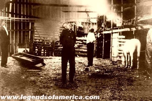
The Hanging of Jim Miller (April 19, 1909)

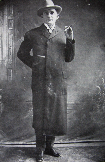
Today marks the 100 year anniversary of the hanging of Jim Miller along with three others for murder. Your probably not going to hear about this anniversary in the local news; I don't think anyone has mentioned it online. I thought I would do it here.

I read about some really creepy people some times. Jim Miller is definitely one of the most creepy old west characters you will find.

I am not going to rehash his life since others have done it better elsewhere. I will give a few links below. Jim Miller is an interesting old west figure because on the outside he appears like a gentleman, church going, likeable individual, but on the inside was a ruthless ambush assassin with a shotgun. He got the name Deacon because he went to church and, supposedly, did not have a habit of smoking or drinking and he looked like what you would expect from a "Deacon."
He got into a feud in Pecos, Tx. with a Sheriff Bud Spencer. Spencer tried to kill him twice and on both occassions that he got the job done, but Miller was wearing his iron plate on his coat. Remember, "aim for the heart," in Fistful of Dollars? Same thing. Miller eventually ambushed Spencer at a local saloon with his shotgun. John Wesley Hardin, his cousin by marriage, helped Miller by being his lawyer in El Paso, Tx. Jim Miller always found a way to create an alibi for his killings. The following picture is rather famous. He was eventually caught, and before he could go to trial he was lynched in Ada, Oklahoma. He is the one on the far left with his hat on.


You have to hear the following interview:
Radio Interview on Jim Miller with Bill O'Neal on Chronicle of the Old West
The Jim Miller Wikipedia Article
Jim Miller's Gravesite
The Daily Ardmoreite Newspaper Article from 1909
Shotgun For Hire (OOP, but you might be able to find it at a library or a used copy)

Sunday, April 12, 2009

The Mt. Whitney Range of Light

Happy Easter!

Before:

After:

This was done at the crack of dawn at around the middle of the 97 switchbacks. Mt. Muir looks the highest here on the left, but Mt. Whitney is the one to the right with the ice at its base.

Monday, March 30, 2009

The Silence of Mt. Dana (Part 5: Finale)

This blog will wrap it up the Mt. Dana hike.

Let's look to the east side which is really the main reward of the hike. There are a few high areas that block some of Mt. Dana from Mono Lake. You can see the very tip of it from down below, but these mountain peaks are what block it. It is all connected to what is called Dana Plateau. Sometime in the next few years I want to go all the way to the end down below. I will take pictures from down below back to where I was standing up here.

The highlight picture everyone tries to get is Mono Lake. Naturally, I was there a little too early in the day with the sun still on that side so it is a little more hazy that I would like, but it will do.

In one of the High Plains Drifter videos I mentioned that I was trying to find the "town" the movie was in from on top of Dana. Well, here is the picture. You can see the South Tufa formations to the right of the picture. Well, just move along the shore to the left and there is where the town would have been. I told you this all connects like a big puzzle.
This is looking toward the north again. Mt. Conness is to the far left and Matterhorn Peak is the the far right.
Mt. Conness. This was about a week before I climbed that one. It is interesting to see pictures of that mountain from different sides.
Naturally, I always keep tabs on my icon peak: Matterhorn Peak. What was funny about this one is if you look closely or click the picture you will see a small heart shaped piece of snow. This is always on there for most of the season. When I have hiked that mountain I always shoot for that heart of ice. Once around it the hard part of the hike is over. However, being a dry year the heart shaped piece of ice was gone the next week.
So, there you have it. A rough hike on the legs, but very rewarding with the views. I only wish I had done it earlier in the season with snow on the mountains. Maybe someday.

Sunday, March 29, 2009

The Silence of Mt. Dana (Part 4)

Everything you see on this side is Yosemite. Mt. Dana, like Conness and Matterhorn Peak, strattle the border of northeastern Yosemite. In the middle right background would be Yosemite Valley, but you can not see it very well from up here compared to the views from Mt. Conness.

This is starting to look toward the southern side.
I zoomed into Mt. Lyell here which is the highest point in Yosemite which is only about 60 feet higher than were I was standing on Mt. Dana.
This is an unknown lake to me. There were a bunch of lakes like this on this side that I do not think I have seen before on the ground.
This is the south side. Can you see a lake in the upper left part in the background?
That looks like Lake Crowley. It is about 35 miles away.
I will try to wrap this up with the next blog.

Saturday, March 28, 2009

The Silence of Mt. Dana (Part 3)

Originally, this was going to be the final blog on this hike, but I am going to extend it.

All the rest of the pictures are from the summit. After looking at the pictures I realized that this is a good area to show the connections to other areas I have mentioned before on this blog. The following is looking to the northern side. In the background I think are the two twin peaks that I showed from the other side in regarding Belle Starr's Daughter; I will have to check up on that though. I believe Mt. Warren is the peak to the right. Tioga Peak, which I climbed a few years back, is much lower to the middle left of the picture. Saddlebag Lake is what you see on the extreme left side of the picture. More on that lake below.
We are still looking in the northern direction here, but I moved the camera a bit more to the left from the above. Tioga Peak is now in the middle right of the picture; it is kind of hard to show because it blends in with the rest of the peaks. Saddlebag Lake is in the background. Tioga Lake is dead center. The peaks of Conness and Matterhorn are in the background, and I will show zoomed in pictures of them in the next blog or two.
I have good memories of Tioga Lake. My dad and other relatives liked to fish this lake once in a while. You can barely see a small rock formation that is in the lake that is obvious when you drive by it.
Here is Saddlebag Lake. When I did that blog entry last week I totally forgot I had a picture of the boat that takes people across the lake. The same situation happened when I zoomed in while on top of Conness.
This is looking toward the western side of Yosemite. From here I was able to zoom back in on the car 3,000 ft. and 3 miles below.
I will continue to show the south and east sides in the next blog.

Friday, March 27, 2009

The Silence of Mt. Dana (Part 2)

We continued that morning at our very slow pace. I was not used to doing a hike this slow. It was really hard for me to speed my legs up. We were right on time though because it takes about an hour for the average person to go up a 1,000 ft. vertical like this. In the picture above you can see the rocky peak that was to the left of Mt. Dana coming up. It was in the first picture in the last blog. Another route one can take is from that direction starting out near Tioga Lake. I tested it a few years ago and it is a good class 2 route, but you eventually come to this point anyways. As far as I can tell it is the same amount of work either way with maybe some more rock scrambling on that side to get to this point. The picture below again shows how steep this area is. With something like this you just have to tell yourself to keep moving and not think of it. Slow, but steady is the attitude one should have. Usually, I get to the top of where this picture is and then see that I have more to go until it flattens out a bit. That was only partially true here.
This is looking back down. You can see two men coming up on the trail. If you look way down there you can see the eastern entrance station to Yosemite, the trailhead, and where we parked.
Eventually, about half-way up, there is a plateau with a rocky cairn (you see this in the video with my backpack and hiking pole against it; also, part of it is visible in the last picture below). It does not really flatten out too much here, but this is the resting point that marks a few things. One, you are half-way, but more importantly, two, the clearly defined trail is about to end. The scramble over rocks is about to begin.
The above is more toward the west. This does show the plateau is big! The picture below is again looking back down.
Mt. Conness is the high point to the left in the following picture. If you look closely you can see Saddlebag Lake in the middle right side of the picture.
After all the work it took to get here we still had to get to the top of this, but the bad news is most of this would be a rock scramble.
I should have up the concluding video and pictures over the weekend.

Thursday, March 26, 2009

The Silence of Mt. Dana (Part 1)

(GPS: N°37 54. 010 W°119 13.280)

Here is one I have wanted to show for a while. I am going to take a few blogs for it. With all the hikes I consider "major" hikes I tend to take hundreds of pictures, but only show about 30 pictures at most in these blogs.

Mt. Dana is one my brother had wanted to do for a few years. I wanted to do it, but not as much as other mountain hikes. The time seemed right so we went off to do it. I should mention that I started to compose the "Why I Do I Climb?" blog in my head the few days before this hike and after it. Part of the problem is we had to wait around to do this one which created a bit of anxiety in me. I knew I would be alright once we got going, but waiting around and thinking about it was bothering me. I was not really enjoying being in the Eastern Sierra those few days before it. The day arrived and the next thing I knew we were at the trailhead. Okay, here we go, 3 miles and over 3,000 ft. in about 3 hours to get to the top.

You can see Mt. Dana from the trailhead that starts at the Eastern entrance to Yosemite. I do not know what that lower rocky peak is called to the left. I will show a picture of it looking back down in my next blog. Now keep in mind we actually started the hike early in the morning before the sun came up. My basic strategy is I rarely take pictures or video in the morning to save battery because I would rather have the sun out for lighting. So, most of what you are seeing is done in reverse order on the way down, but I do it this way so you get to see it in good daylight conditions.
You pass a lot of these little ponds on the way in the early part of the hike. The first 20-30 minutes is easy just walking through a forest with lots of trees.
I have read that earlier in the year after spring the flowers are really nice up there. Unfortunately, I was there at the end of summer. I still was looking for whatever nature pictures I could get. After meandering through the forest for the first 20 minutes we finally got a taste of what the hike was really going to be about.
This is probably the steepest hike I have ever done. I may have been in areas where short portions of a hike were steeper, but this is just straight up the rest of the way. Sometimes I can go up steep portions of a hike really quickly and then recover slowly on the rest of the hike. I tried going fast, but it just did not work that way here. I realized I was just going to have to put one foot above the other at a very slow pace. I felt like I had no choice.

Wednesday, March 18, 2009

Huell Howser's California's Gold: Glacier (Program)

For those that do not know who Huell Howser is he does a show on California PBS stations called "California's Gold." He goes to some unique town or area, interviews some guides there, and shows the importance of it from a historical, scientific, or just natural beauty perspective. He always has a cheerful personality no matter what the topic.

I do not watch everything Huell Howser does, but once in a while I will come across something that will keep my full attention on the whole episode. Monday's episode called "Glacier" was one of them. If you have read this blog then you will know this area, or the very nearby areas, comes up once in a while.

Usually, I do not talk about other people's adventures on here, but since Huell is an influence on how I do things, and this area is one that I love, I just wanted to talk about it. In the following screen capture Huell is on a boat crossing over Saddlebag Lake. This is one of those times that I wish my dad could have seen this episode since we took this type of boat across the lake to fish a few times. You could take the boat to the other side of the lake and then be picked up 12 hours later. They just did it to avoid hiking around the lake which I have done too.

This is Greenstone Lake. It has a green look to it and they explain why these lakes look green in the episode: the glacial tarn elements cause it. This is the lake my dad liked to fish at.
I am moving on to the end of the episode with Huell, and the crew he was with, got to this point to talk about the glacier. I think for most people this may not be that impressive to see. There is not that much glacier there because it is slowing receding. It does look more impressive with more snow earlier in the year. Two things here that were amazing to me to see on tv: Mt. Conness is the right hump which they did mention. The lake is one of Conness Lakes which has the turquoise color to it (the glacial tarn). For Huell to get here was more fun for me to see than the glacier. Here is the zoom in of the glacier.
Okay, my turn! I am going to add some pictures that I did not use from when I posted in November about my hike to Mt. Conness. Here is the glacier they are trying to show from above:
I posted a few pictures like this in November. This is slightly different. It shows the top parts of the glacier and the lakes around. Saddlebag Lake in the middle background which they crossed by boat, then Greenstone Lake mentioned above, and then they reached one of Conness Lakes on the left side.
I believe they got to the lake in the back. The lake in the foreground is much higher up with what looks like a wall from where they were at. I had intended to do something like what Huell did after my hike last summer. The last time I was there the weather was too stormy. I do intend to go back and take new pictures. I have been on the trail that loops around all the lakes in the distance. That was about 13 years ago if I remember correctly.

My series on Mt. Conness is in the following entries:

Part 1

Part 2

Part 3

The Conness Survey Crew of 1890

Huell went to another area nearby that I intended to show later this year at some point. Maybe I will show it next month.

Friday, March 13, 2009

Waterhole #3 (The Red Rock Canyon Series)

(GPS: N35° 21.850 W117° 58.390)

This location is important in the movie because it is the final waterhole James Coburn must go to in order to get the army cache of gold. Here he is below searching in Waterhole #3:
The concrete foundations of the waterhole are still there:
This is in the Red Cliffs side of Red Rock Canyon which is east of the 14 HWY. You can see the rock formations in the background and compare to the above. Carroll O'Connor looks like he is about to get suckered here, but maybe not:
Here is the waterhole looking to the south:

A couple of things about this area. One, as I mentioned at the end of the video, There is a map called the Red Cliffs Nature Trail at the trailhead. It gives you the natural history of the area and shows you the short nature trail around this area. Even though I had a map it still was a bit hard to follow. You do have to go off the trail to find it, and one could go right past it because it is not totally obvious from the trail. BUT, of course, naturally, to everyone's delight, how could I make it more easy, blah, blah, blah...I list the gps coordinates at the top. Use 'em! ;)

I may do something more with the Red Cliffs area you see in the background in the future. It has been used a lot in movies. I remember back in the 1980's the heavy metal band W.A.S.P. used it for one of their music videos (song: Wild Child). You park pretty close to where they shot that video.

Finally, one unfortunate location that I really wanted to get a while back is at the very beginning of the movie. James Coburn gets into a gunfight there. It is just outside Lone Pine near the town of Dolemite. Unfortunately, it is now privately owned by a mining company, and they will keep you off of the area if you go there. I have seen the few remaining buildings as I have driven by. I know during the festival they went there, but I will probably not ever go there. Oh well, there are many other areas.